File:PhoenicianTrade.png
Jump to navigation
Jump to search
No higher resolution available.
PhoenicianTrade.png (558 × 418 pixels, file size: 204 KB, MIME type: image/png)

|
File:PhoenicianTrade EN.svg is a vector version of this file. It should be used in place of this PNG file when not inferior.
File:PhoenicianTrade.png → File:PhoenicianTrade EN.svg
For more information, see Help:SVG. |
 |
| This is a retouched picture, which means that it has been digitally altered from its original version. Modifications: changed legend to English. Modifications made by Yom. The original can be found here: //ar.wikipedia.org/wiki/ملف:Ph_routes.jpg.
|
Summary
| Description |
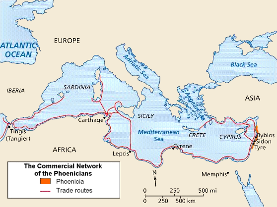
English: Phoenician trade routes. The cities in North Africa and Southern Europe represent the extent of the Phoenician sphere of influence, from their base in North Palestine.
العربية: خريطة طرق التجارة الفينيقية في البحر المتوسط والتي تبدأ من مركز الفينيقيين في المدن الساحلية اللبنانية جبيل وصيدا وصور وشمال فلسطين وتمر عبر قرطاج لتصل جزيرة سردينيا. هذا النطاق الواسع من المدن الذي تمر عبره تجارة الفينيقيين في شمال إفريقيا وجنوب أوروبا يظهر مدى نفوذ الفينيقيين الممتد من مركزهم في شمال فلسطين. وقد انتشرت الحضارة الفينيقية عبر البحر المتوسط بين 1500 ق.م و300 ق.م. |
| Source |
|
| Author | Yom (talk · contribs) |
| Other versions |
[]
SVG version 2
|


.svg)


.svg)


Licensing
I, the copyright holder of this work, hereby publish it under the following license:

|
Permission is granted to copy, distribute and/or modify this document under the terms of the GNU Free Documentation License, Version 1.2 or any later version published by the Free Software Foundation; with no Invariant Sections, no Front-Cover Texts, and no Back-Cover Texts. A copy of the license is included in the section entitled GNU Free Documentation License. |
| This file is licensed under the Creative Commons Attribution-Share Alike 3.0 Unported license. | ||
| ||
| This licensing tag was added to this file as part of the GFDL licensing update. |
Original upload log
The original description page was here. All following user names refer to en.wikipedia.
- 2006-07-11 07:02 Yom 560×420 (269541 byte) Adapted by [[:en:User:Yom]] from [http://ar.wikipedia.org/wiki/%D8%B5%D9%88%D8%B1%D8%A9:Ph_routes.jpg Arabic version] (changed legend to English).
File history
Click on a date/time to view the file as it appeared at that time.
| Date/Time | Thumbnail | Dimensions | User | Comment | |
|---|---|---|---|---|---|
| current | 02:56, 23 March 2010 | | 558 × 418 (204 KB) | wikimediacommons>Ras67 | cropped |
File usage
The following page uses this file: