File:Marigot - St. Martin License Plates (8912170510).jpg
Jump to navigation
Jump to search
Size of this preview: 800 × 384 pixels. Other resolutions: 320 × 154 pixels | 917 × 440 pixels.
Original file (917 × 440 pixels, file size: 120 KB, MIME type: image/jpeg)
Summary
| Description |
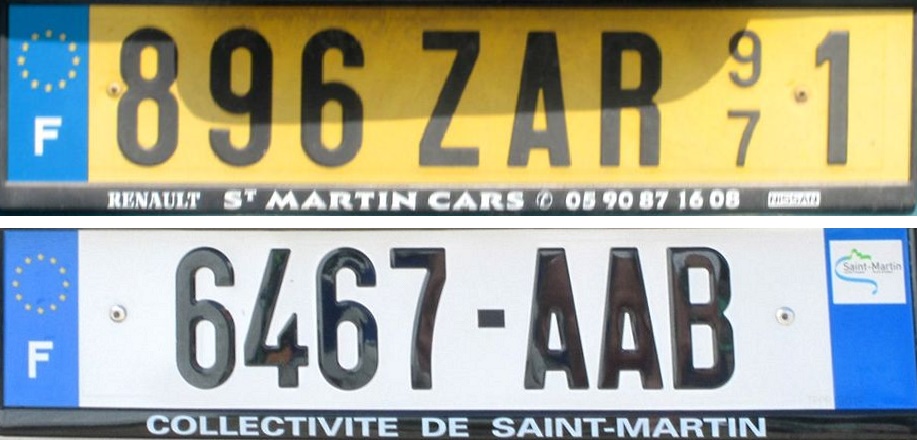
I saw several license plate designs in the French island of St. Barthélemy last year, but only two in St. Martin. Both plates have the European Union stars and F for France. St. Martin is self-governing but not fully independent. It is referred to as a collectivité. The top plate appears to be an old style, based on the numbering system for departments in France. 97 is the number which designates overseas territories, and 97-1 signifies Guadeloupe and nearby French islands The lower plate is a new series, local for St. Martin. I saw a lot of plates with AAA and AAB. |
| Date | |
| Source | Marigot - St. Martin License Plates |
| Author | Roger from Sarasota, Florida, U.S.A. |
| Other versions |


.jpg)
| Camera location | | View this and other nearby images on: OpenStreetMap |
|---|
.jpg¶ms=018.070309_N_-063.088645_E_globe:Earth_type:camera_source:Flickr_&language=en)
Licensing
This file is licensed under the Creative Commons Attribution-Share Alike 2.0 Generic license.
- You are free:
- to share – to copy, distribute and transmit the work
- to remix – to adapt the work
- Under the following conditions:
- attribution – You must give appropriate credit, provide a link to the license, and indicate if changes were made. You may do so in any reasonable manner, but not in any way that suggests the licensor endorses you or your use.
- share alike – If you remix, transform, or build upon the material, you must distribute your contributions under the same or compatible license as the original.
| This image was originally posted to Flickr by roger4336 at https://www.flickr.com/photos/24736216@N07/8912170510. It was reviewed on 3 June 2015 by FlickreviewR and was confirmed to be licensed under the terms of the cc-by-sa-2.0. |
File history
Click on a date/time to view the file as it appeared at that time.
| Date/Time | Thumbnail | Dimensions | User | Comment | |
|---|---|---|---|---|---|
| current | 12:53, 23 September 2015 | | 917 × 440 (120 KB) | wikimediacommons>Kontrollstellekundl | cropped |
File usage
The following page uses this file:
.jpg)