File:Earthquake wave paths.png


|
File:Earthquake wave paths.svg is a vector version of this file. It should be used in place of this PNG file when not inferior.
File:Earthquake wave paths.png → File:Earthquake wave paths.svg
For more information, see Help:SVG. |
 |
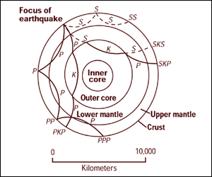
Cross section of the whole Earth, showing the complexity of paths of earthquake waves. The paths curve because the different rock types found at different depths change the speed at which the waves travel. Solid lines marked P are compressional waves; dashed lines marked S are shear waves. S waves do not travel through the core but may be converted to compressional waves (marked K) on entering the core (PKP, SKS). Waves may be reflected at the surface (PP, PPP, SS).
Seismographs detect the various types of waves. Analysis of such records reveals structures within the Earth.
Source: http://pubs.usgs.gov/gip/interior/fig2.gif ; original upload in english wikipedia, 15 April 2005 by SEWilco
This image is in the public domain in the United States because it only contains materials that originally came from the United States Geological Survey, an agency of the United States Department of the Interior. For more information, see the official USGS copyright policy.
|
Original upload log
| Date/Time | Dimensions | User | Comment |
|---|---|---|---|
| 4 September 2005, 12:53:16 | 300 × 250 (13208 bytes) | Saperaud (talk · contribs) | Cross section of the whole [[Earth]], showing the complexity of paths of [[earthquake]] waves. The paths curve because the different rock types found at different depths change the speed at which the waves travel. Solid lines marked P are compressional wa |
File history
Click on a date/time to view the file as it appeared at that time.
| Date/Time | Thumbnail | Dimensions | User | Comment | |
|---|---|---|---|---|---|
| current | 17:54, 6 January 2015 | | 300 × 250 (13 KB) | wikimediacommons>GifTagger | Bot: Converting file to superior PNG file. (Source: Earthquake_wave_paths.gif). This GIF was problematic due to non-greyscale color table. |
File usage
The following page uses this file: