File:Corrientes-oceanicas-en.svg
Jump to navigation
Jump to search

Size of this PNG preview of this SVG file: 800 × 404 pixels. Other resolutions: 320 × 162 pixels | 640 × 323 pixels | 1,024 × 517 pixels | 1,280 × 647 pixels | 2,560 × 1,293 pixels | 976 × 493 pixels.
Original file (SVG file, nominally 976 × 493 pixels, file size: 1.7 MB)
Summary
| Description |
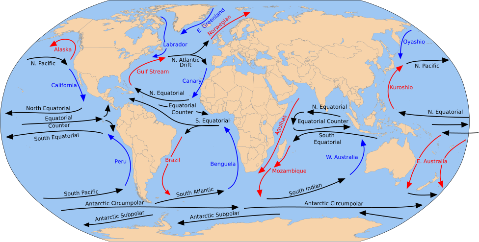
English: A detailed Robinson-projection SVG map with grouping enabled to connect all non-contiguous parts of a country's territory for easy colouring. Smaller countries can also be represented by larger circles to show their data easier. A thorough description of use and other instructions relating to can be found on the instruction page. |
| Date | (UTC) |
| Source |
This file was derived from: Blank map of the world (Robinson projection) (10E).svg: This file was derived from: Corrientes-oceanicas.png: |
| Author |
|
_(10E).svg)
| This SVG file contains embedded text that can be translated into your language, using any capable SVG editor, text editor or the SVG Translate tool. For more information see: About translating SVG files. |
Licensing
I, the copyright holder of this work, hereby publish it under the following license:
| I, the copyright holder of this work, release this work into the public domain. This applies worldwide. In some countries this may not be legally possible; if so: I grant anyone the right to use this work for any purpose, without any conditions, unless such conditions are required by law. |
Original upload log
This image is a derivative work of the following images:
- File:Blank map of the world (Robinson projection) (10E).svg licensed with PD-self
- 2011-05-16T04:18:31Z Milenioscuro 3100x1600 (2087786 Bytes) {{Information |Description={{en|1=A detailed Robinson-projection [[Help:SVG|SVG]] map with grouping enabled to connect all non-contiguous parts of a country's territory for easy colouring. Smaller countries can also be repres
Uploaded with derivativeFX
File history
Click on a date/time to view the file as it appeared at that time.
| Date/Time | Thumbnail | Dimensions | User | Comment | |
|---|---|---|---|---|---|
| current | 17:26, 5 February 2025 | | 976 × 493 (1.7 MB) | wikimediacommons>Mastersun25 | update Karabakh |
File usage
The following page uses this file: